Full disclosure: Being in Florida, I don't spend as much time watching winter weather, and don't have great experience correlating radar precipitation totals to actual snowfall. Is it spring yet?
But I do at least some background and information, and so hopefully can add some insight.
Using radar is certain to have imperfections...
Smaller Radar Caveats:
- Radar beams increase in height with distance from the radar. They really don't tell you what is actually happening at the ground, but instead up at some height aloft... this may mean that, especially further from the dish, light precipitation shown on radar can actually be evaporating before hitting the ground... or you may not get any precipitation showing up at all because sometimes convection can be so shallow that it is only below the radar beam and thus undetected (example [2.5 km ≈ 8200 ft]))
- Radar beams are also blocked by elevated terrain, such that some areas in mountainous regions may not return any data. See for example this map of the regions that are visible to US weather radars, and note the jagged/non-circular shapes common in the west indicative of mountains.
The exact radar setup is very important in determining the utility of the data. In addition to the range and terrain issues, the beam angle and width alter what returns mean, some frequencies attenuate or reflect certain drop/flake sizes better than others, etc... so exact radar details are very crucial.
I was able to dig up this site that shows the range outlines of nine Japanese radars and then the full JMA radar specs page. Looks like probably the radar spacing is pretty quality generally, but the frequencies are quite different than the radars I'm used to. In the end, understanding the nuances and return characteristics of a radar's setup can be a very intensive life-long process for even the best of meteorologist!
Greater Complications of Estimating Snow
- Also note that winter precipitation adds an extra complication because the particles are lighter in weight and can thus be blown about more by vertical and horizontal winds. Raindrops (and hail) are quite likely to fall unless extreme updrafts exist because they are heavy. But drizzle, snow, and sleet may be blown around quite a bit. Without a time-intensive dual-Doppler analysis, you cannot know the wind motion in the storm thoroughly, and therefore will have varying results at times.
- And finally, the big wrench is unfortunate inherent to how radars work. They measure the percentage of their sent energy that is reflected back to them. That's great because that's directly connected to the diameter of the item falling (to the 6th power). But unfortunately the grand problem is that in a storm, there is a huge variety of drop/flake sizes mixed together at once... such that we can't extract which combination of particle sizes created it (and thus can't calculate volume to actually know the rain/snow amount that falls). It could be like 6 medium size flakes causing the 10 dBZ echo... or 2 large flakes and 10 small flakes... and each combination is a different volume/snow total. (to see the nitty-gritty math details on this, read more here.) So we can never know for sure the exact rain/snow falling using just radar. The good news is we've at least done lots of experiments and come up with some fairly useful best-practice formulas for using the Z-R ratio in different scenarios. Good, but not perfect.
- But when it comes to winter precip, it gets even uglier. For one, the reflectivity of ice is way more than water (making it look like a ton is falling!)... but we typically can determine where the changeover line to ice is and work from that. But the bigger issue is that ice crystals form an amazing range of shapes. And you can imagine that each of those is going to reflect a radar beam in different percentages... and then take up different amounts of room on the ground. In the US, the switch to polarimetric radar has helped with the shape issue a fair bit. But if you don't have that in Japan, you could have quite a bit of error in some formation regimes. Regardless, we have certainly come up with a few fair rules of thumb for winter precip, such as discussed in this article, but they're far from perfect.
Now that doesn't mean working from radar isn't helpful. The "precipitation nowcasts" are probably better for you, taking out the complexity of all that Z-R relationship stuff just mentioned to just give you a mm/hr (though the site may well not be taking enough into account to give worthwhile values in all situations). But you can have some comfort from the fact that in the US we do regularly use basically the same idea to what you're doing to identify floods and even roughly track snowfall areas. But unfortunately it's a real pity it doesn't seem most countries like Japan offer as many detailed radar products for free as we get. In the US, the NWS gives us storm-total precipitation plots directly, which provides us the total return accumulation (since last reset) so we don't have to track the aggregation ourselves. Plus we have direct access to the full radar data files, which would remove the overcome the value stratification issues from the imagery and simplify the process. But unfortunately I couldn't find anything about any rawer data files in my searching other than for the US site in Okinawa.
Your method does sounds fairly decent, particularly for Nagano since it appears to have it's own radar (based upon that earlier list). I do imagine it'll still have some errors at times, being off by a fairly decent percentage sometimes. Even here in the US, we're only just starting to cautiously venture more into more high resolution official snow analyses. So it won't be nearly perfect, but it'll probably have some reasonable utility, and perhaps is your best method on this avenue.
However, I want to give you a couple more options that may well end up being better for you, depending upon your interest:
Initial model plots:
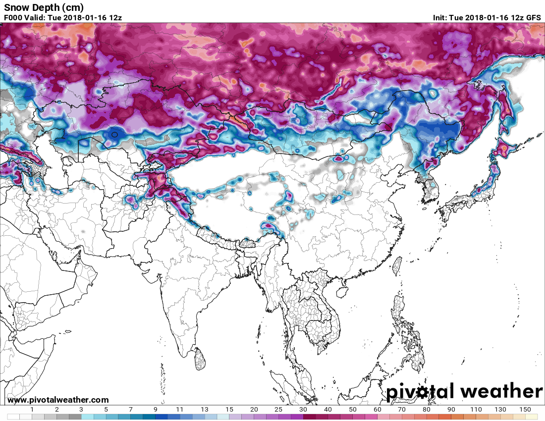
Global models, like the American GFS, use large amounts of data to create their initial conditions. And so among their products, they offer current snow cover plots. Pivotal Weather offers a useful tool to mouseover and get values at any point in a plot like this one:

Don't know if it's perfect for you, as the GFS resolution is around 30 km, so even at maximum resolution it's going to lump some mountains and lower areas together. A pity Pivotal Weather also is a little zoomed out in your area. If you were really wanting to go all in, you could definitely dig up the data files to download the data directly out of the model for peak resolution and information. Otherwise if content, you can just check each day (or every 6 hours) and compare to the previous image (which you can pull up in the dropdown on Pivotal's site).
Satellite data:
I was able to come across one satellite that does offer a snow analysis product, the NASA TERRA/MODIS pair. On that same page they have a further link to download the data at 0.05 degree resolution, which would be less than 1 km!!! I have no idea how good these plots are, but the potential sounds great.
So just maybe model and satellite can offer to bypass some of the flaws of radar data (though just may add their own challenges). All of it is likely better than relying on the town's reporting station... it's unfortunate there's a lack of reliable reporting stations on mountains (but it's a problem we have here too, and a matter of simple economics/utility). But hopefully those help you better get the data you wish for! Happy skiing :-p
