6
$\begingroup$

First question on this StackExchange, so here goes...

Overall, reaching high temperatures is dependent on 2 factors:

  1. The (maximum) solar angle in the day. The greater the solar angle, the more insolation is received by the surface and air, allowing higher maximum temperatures assuming no thermal inertia.
  2. The length of the day. The longer the day, the more total solar radiation arrives in one 24-hour span, and the shorter the night is to radiate off excess energy, both of which due to the thermal inertia of the atmosphere and ground bias them towards hot temperatures.

(Again due to thermal inertia, it may be dependent on the day length and solar angle of previous days, though this influence is more minor.)

The first factor explains why even though at the summer solstice the poles accumulate more solar energy over 24 hours than any other place on Earth (I know I had a source on this. I can't find it, though.), they are still extremely cold as the low solar angle prevents reaching higher temperatures. The second factor explains why even though the equatorial region has the highest average maximum solar angles throughout the year, they don't get especially hot (even in rare desert areas) as the day length is nearly constant throughout the year.

Ergo, the outer tropics and the subtropics experience the hottest extreme maximum temperatures on Earth. This can be seen in the records for each continent that has a large stretch in that area:

  • America (South): 48.9 °C in Rivadavia, Argentina (24.18[3]° S)
  • Africa (South): 50 °C in Dunbrody, South Africa (~33.4° S)
  • Australia: 50.7 °C in Oodnadatta, South Australia (27.54811° S)
  • Africa (North): 51.3/53.5 °C in Ouargla, Algeria (31.95° N)
  • Asia: 53.9 °C in Mitribah, Kuwait (29.81[6]° N)
  • and lastly, America (North): 54.0/54.4/56.7 °C in Furnace Creek, California, USA at a rather high 36.458056° N.

Presumably, the spread in latitudes is due to the geography in those areas being much more suited to the generation of extreme heat than places at the "absolute ideal latitude". But what is this absolute ideal latitude? At what point from the equator do the combination of day length and solar angle in summer create the most optimal conditions for extreme heat, other factors being equal?

(My scientific wild ass guess is 30°, but I'd like a more educated answer.)
$\endgroup$
6
  • 1
    $\begingroup$ 3. Climate: Continental, oceanic? - 4. Height: Sea level or in the Andes? - 5. Time of year: Winter solstice? 1st of April? Sometime in August? $\endgroup$
    – Erik
    Commented Aug 9, 2019 at 6:48
  • $\begingroup$ Note what I said near the end of the question: Other factors being equal. For instance, while a place that, say, experiences 10 m of precipitation a year with 300+ cloudy days and is heavily influenced by an offshore cool current at [x] temperature would experience mid-summer temperatures far lower than what it would if it were continental and bone-dry, they'd still be higher in mid-summer at this latitude than places with the same external factors at different latitudes. Understand? By mid-summer I mean the thermal peak of the year. $\endgroup$ Commented Aug 9, 2019 at 17:26
  • $\begingroup$ @GrantHartlage, i think your premises disregard the factors that have more influence on local weather than solar insolation/area. Earth's axis obliquity, continental arrangement, circulation, cloud cover, ground composition play a bigger role than mere latitude. You will find the hottest places not at an absolute latitude, but more in a continental climate, away from the equator in the Hadley cells where the trade winds blow and high pressure prevails. $\endgroup$
    – user18607
    Commented Jan 6, 2020 at 13:03
  • $\begingroup$ Are you talking about Earth, or about a hypothetical idealised spherical cow planet in vacuum planet? If you are talking about Earth, then "other factors being equal" simply doesn't apply, as each latitude band has its own unique geography. If you're talking about an idealised perfect planet, you need to define your parameters and feed them into a model (which can be quite simple for an idealised planet), but the result will have little to do with Earth. $\endgroup$
    – gerrit
    Commented Jan 6, 2020 at 17:02
  • $\begingroup$ This map has "Summer Daytime Maximum Land Surface Temperature". It's not clear to me whether you are asking about this, or record highs. $\endgroup$ Commented Jan 8, 2020 at 2:16

2 Answers 2

1
$\begingroup$

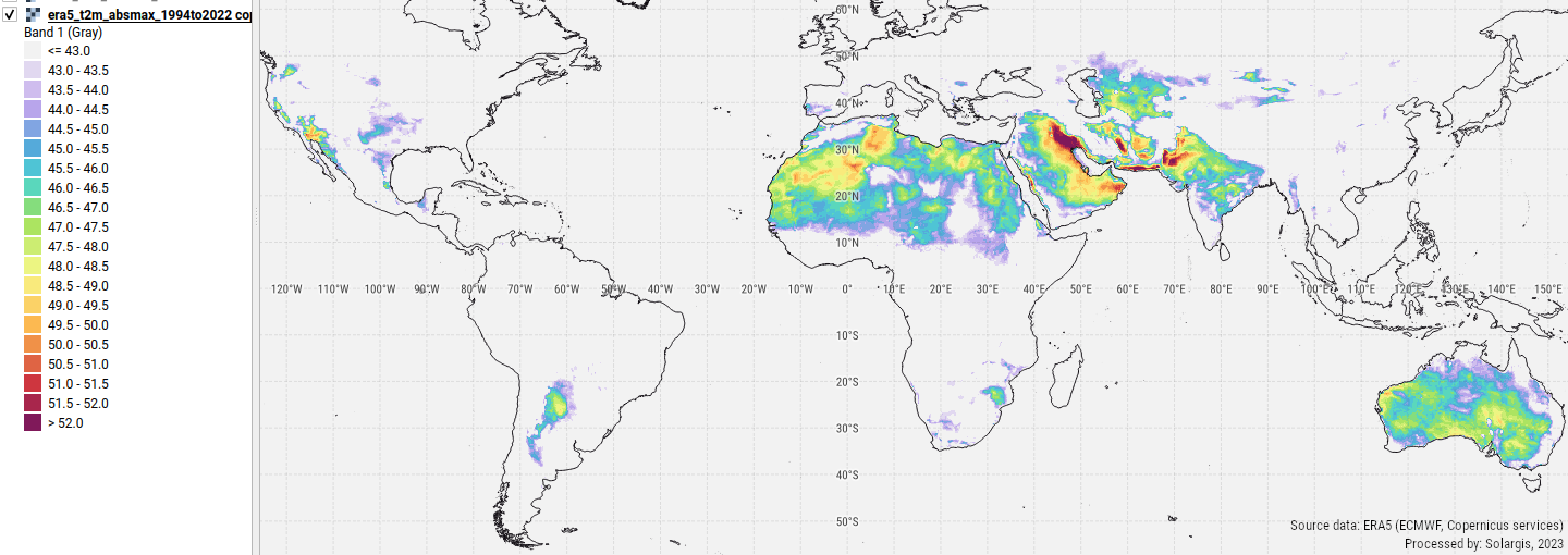
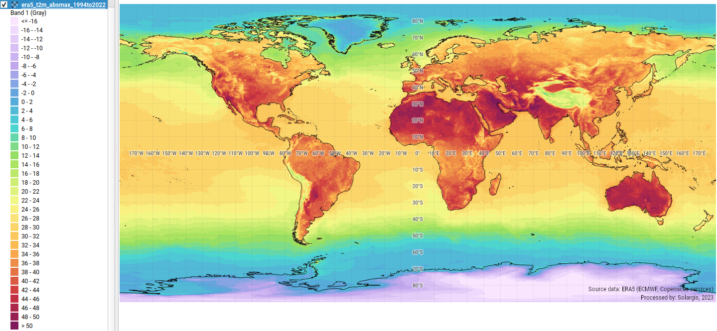
Interesting question. I made a quick analysis based on ERA5 climate reanalysis. The maps below show the absolute maximum air temperature at 2 m height above ground (or simply air temperature), derived from latest 29 years (period 1994-2022). You find clear indication of the hottest regions.

Global map of the absolute maximum air temperature enter image description here

The same map with the focus on the regions with highest documented air temperature enter image description here

Note, that (of course) measured data by meteorological station locally can (slightly) differ from modeled ERA5 data.

$\endgroup$
-2
$\begingroup$

The places that get the hottest temperatures are close to the equator but not necessarily on the equator. They will be low lying places, perhaps below sea level, and 'enjoying' a continental climate. For the record books, they will also need to be places where a climatologist passes through at the right time to measure it. I see you mention some record temperatures in your question, but I don't remember off hand what the absolute world record temperature is. It won't be far short of 55 C, but what amazes me is how the people who measured such temperatures survived to tell the tale. The atmosphere must have been very dry. From the point of view of human wellbeing, in high humidity temperatures well short of world record don't feel well short, and are almost as dangerous.

$\endgroup$
3
  • 2
    $\begingroup$ This is again incorrect, like so many of your posts. The hottest places on earth are in deserts well away from the equator. In contrary, tropical climate is pretty constant. $\endgroup$
    – user18607
    Commented Jan 6, 2020 at 12:28
  • 1
    $\begingroup$ You don't need anyone to pass through the area at the right time to measure it, unstaffed weather stations are not all that bad at measuring temperature. And what do you mean by "close"? Is Death Valley at 36°N "close" to the equator? $\endgroup$
    – gerrit
    Commented Jan 6, 2020 at 16:59
  • $\begingroup$ It's well below sea level, and that makes a difference. And there are not unmanned weather stations everywhere. $\endgroup$ Commented Jan 6, 2020 at 18:35

Your Answer

By clicking “Post Your Answer”, you agree to our terms of service and acknowledge you have read our privacy policy.

Not the answer you're looking for? Browse other questions tagged or ask your own question.