11
$\begingroup$

Intuitively, it makes perfect sense to think that the coldest day of the year would be the day that gets the least sunshine, the winter solstice. In the northern hemisphere, this occurs a few days before Christmas. But as anyone who lives in places that gets snow can tell you, the most bitter parts of winter are in January and February, not December.

Why does it get so much colder when sunlight (and the warmth it should be bringing with it) is increasing?

$\endgroup$
2

1 Answer 1

13
$\begingroup$

Primarily because of inertia. This phenomenon is called seasonal lag.

It is true that the December solstice is the moment that the northern hemisphere gets the lowest total amount of insolation. Conversely, the June solstice corresponds to the moment of maximum insolation. The oceans, and to a lesser degree the land, absorb a lot of heat. Due to the large heat capacity of water and the large amounts of water, the seasonal lag can be considerable. In general, mid-latitude areas near large bodies of water have the largest seasonal lag, to the extent that the warmest month of the year in most of western Europe is August.

It is illustrated very well by this Warmest day of the Year map that NOAA NCDC (now NCEI) produced for the contiguous United States:
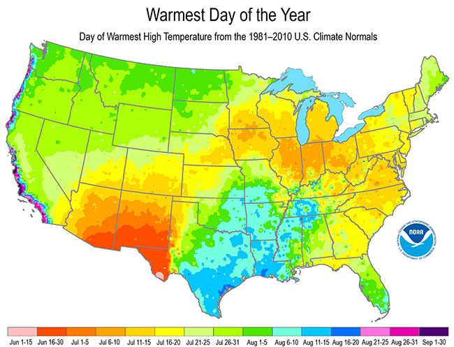
NCDC/NCEI map of warmest day of the year

As expected, areas with a humid climate, such as southern Texas and nearby areas, tend to have the warmest day of the year in August. The west coast is even more extreme, with some places having the warmest day in September. Conversely, desert areas in the southwest (southern Arizona, New Mexico, western Texas) have the warmest day of the year in June. (For the Big Bend area in Texas, it's even in the first half of June, which has different reasons; I'm no expert on the climate of the region, but according to a comment by David Hammen, it's due to the North American Monsoon. July and August are much cloudier (and occasionally, much more rainy) than is June in the Big Bend area). There is a corresponding map for coldest day of the year:
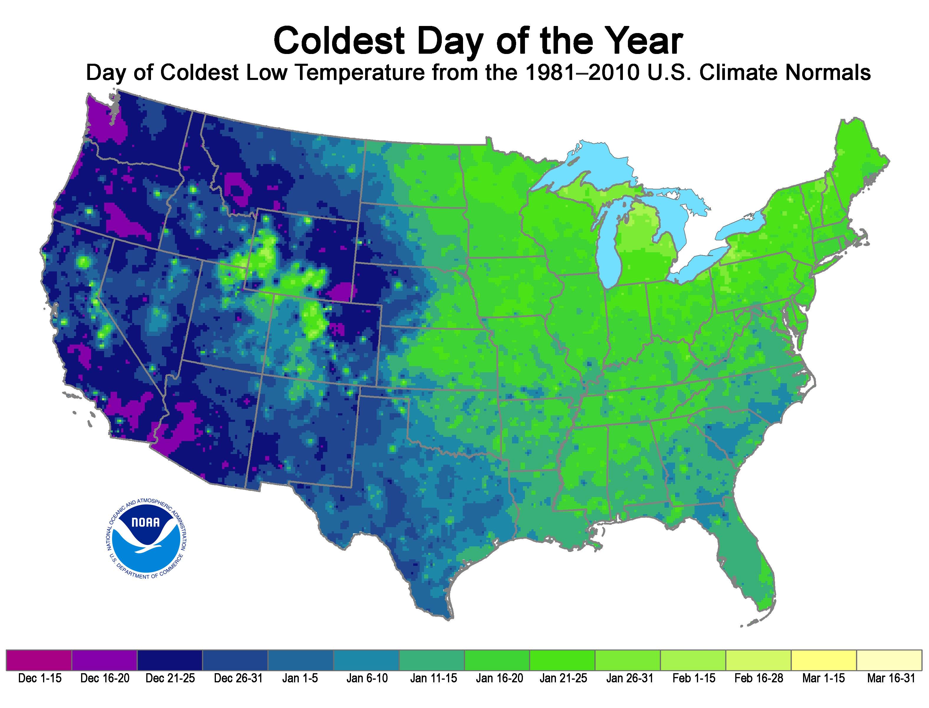
Coldest day of the year
(Source: NCEI)

The detailed structure is somewhat different, which has to due with local climate and circulation, but the overall trend related to humidity and proximity to ocean shows up in both. We can also see the mountains, which I would guess to be a snow albedo feedback effect (ever notice how nights get colder when the ground is snow-covered?). At NCEI you will also find similar maps for the rest of the USA as well as updated information focussing on the 1991-2020 timeframe.

$\endgroup$
5
  • $\begingroup$ I see so many charts like these nowadays. No label for the axis. No unit. No explanation. After looking at it for 10 minutes, I finally understand: for Chart 1, if the location is marked "purple" or "violet", that means its warmest month is at the end of August or in September... $\endgroup$ Commented Jul 4, 2023 at 16:57
  • $\begingroup$ Then I don't understand why Boston or the East Coast, when it can store a lot of energy in the ocean too, why is it not behaving like the West Coast? $\endgroup$ Commented Jul 4, 2023 at 16:58
  • $\begingroup$ @StefanieGauss The label with the unit is right there below the map, incidating the date of the coldest day of the year. I don't know what more there is to explain. The east coast has less seasonal leg than the west coast because prevailing winds in this latitude are from the west, so the west coast typically has a wind from the ocean whereas Boston typically has a wind from the land. $\endgroup$
    – gerrit
    Commented Jul 4, 2023 at 20:06
  • 1
    $\begingroup$ An updated (1991-2020, as opposed to 1981-2010) version of the map for the warmest day of the year is at When to Expect the Warmest Day of the Year. $\endgroup$ Commented Jul 5, 2023 at 8:49
  • 1
    $\begingroup$ Regarding "For the Big Bend area in Texas, it's even in the first half of June, which must have entirely different reasons (probably related to dynamics) because a negative seasonal lag doesn't make much sense." That's due to the North American Monsoon. July and August are much cloudier (and occasionally, much more rainy) than is June in the Big Bend area. The warmest day of the year in Terlingua, Texas is June 11 -- well before the solstice. $\endgroup$ Commented Jul 5, 2023 at 8:53

Your Answer

By clicking “Post Your Answer”, you agree to our terms of service and acknowledge you have read our privacy policy.

Not the answer you're looking for? Browse other questions tagged or ask your own question.