12
$\begingroup$

Under this answer there's a comment:

I am not aware of any location having its hottest temperature in winter...

and for mid-to-polar latitude folks specifically we first learn that our summer is the hottest and as we get older we learn that half of the planet has summer during our winter, and that folks near the equator may have more complex weather patterns than summer=hot, winter=cold.

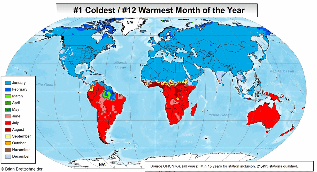
Question: Are there some places near but not on the equator that are hottest in their winter and some that are hottest in their summer? Is there a map of this? Perhaps something indicating the hottest month of the year by color?

I can imagine in the South it will be January and in the North it will be July (or similar, but near the equator I'm expecting a more complicated pattern, but have no idea what it would look like.

$\endgroup$
0

2 Answers 2

19
$\begingroup$

Tropical climates usually aren't subject to typical extratropical seasons and are instead characterized by rainy/dry seasons. However, if you define the "summer" and "winter" using the typical nothern/southern hemisphere convention, rather than by local vernacular in the region, then the answer is yes. According to the Global Historical Climatology Network–monthly (GHCNm) dataset, a set of monthly climate summaries from thousands of weather stations around the world, there are areas in South America near the equator that appear to satisfy this condition. However, these places are really just warm all year long and have little difference in the hottest and coolest months. See below images from Brian Brettschneider. I think Balsas, Maranhao, Brazil is a good candidate:

warmest day of year

...

coldest day of year

$\endgroup$
8
  • 4
    $\begingroup$ Well, if it's the #1 warmest, then by definition it is also the #12 coldest. $\endgroup$
    – f.thorpe
    Commented Jul 4, 2021 at 3:56
  • $\begingroup$ oh yes, it's simply redundant and I was trying to read more into it :-) $\endgroup$
    – uhoh
    Commented Jul 4, 2021 at 3:58
  • 5
    $\begingroup$ Interesting that the coldest month is very consistent, with the clear dividing line, but the warmest month is not - presumably because the rainy season reduces temperatures in the “summer”, shifting the warmest month earlier (or later)? $\endgroup$
    – Tim
    Commented Jul 4, 2021 at 6:43
  • 2
    $\begingroup$ @Tim Look at India, and to a lesser extent, the portion of Southeast Asia north of the equator. While north of the equator, the Indian subcontinent's and Southeast Asia's warmest month is March or April rather than July or August. The South Asia monsoon starts in June and lasts until September. The Sahel and Central America also have rainy seasons that prevent July and August from being the warmest months of the year. The Intertropical Convergence Zone (ITCZ) moves north and south and back again over the course of a year, and reaches its northernmost location in August. $\endgroup$ Commented Jul 4, 2021 at 14:47
  • 1
    $\begingroup$ @gerrit It's caused by the influence of Arctic Ocean which warms up slower than the land, whereas ice has a higher albedo than the ocean where more heat is being reflected. On Wikipedia this is also described under seasonal lag. $\endgroup$
    – Toby Mak
    Commented Jul 6, 2021 at 12:36
6
$\begingroup$

The temperate concepts of winter and summer don't quite apply to the tropics, the region between the Tropic of Capricorn and the Tropic of Cancer. That region experiences two maxima and two minima per year in terms of top of the atmosphere (TOA) insolation. The solstices mark the times at which TOA insolation is at a minimum at the equator. The equinoxes are when TOA insolation is at a maximum at the equator. At or near the equator, it is cloudiness and rainfall (or lack thereof) that dictate when the coolest and warmest months occur.

Cloudiness and rainfall can greatly reduce insolation and temperatures at the surface. The Intertropical Convergence Zone (ITCZ) provides a lot of cloudiness and rainfall in the tropics. The ITCZ moves north and south and back again over the course of a year. The northward motion of the ITCZ in Northern Hemisphere summer explains why the Sahel and Central America do not experience their highest temperatures in July or August.

The ITCZ reaches its northernmost location in those months. Coupling this with the fact that TOA insolation is at a minimum on the June solstice at the equator, it should not be surprising that parts of Brazil that are south of the equator experience their warmest temperatures in July or August.

$\endgroup$
2
  • 1
    $\begingroup$ If you want a very bumpy ride, book an airplane flight that crosses the equator. Veering around an active region of the ITCZ might require a 1000 km long-cut. If that's the case, the pilot will fly over the ITCZ, and will try to skirt the very tallest thunderclouds that punch well into the stratosphere. But the pilot will not be able to completely avoid all of the updrafts and downdrafts. $\endgroup$ Commented Jul 4, 2021 at 15:57
  • 1
    $\begingroup$ "That region experiences two maxima and two minima per year in terms of top of the atmosphere (TOA) insolation." It's logical, but I never thought about it before. Thanks for the informative answer! $\endgroup$ Commented Jul 4, 2021 at 17:31

Your Answer

By clicking “Post Your Answer”, you agree to our terms of service and acknowledge you have read our privacy policy.

Not the answer you're looking for? Browse other questions tagged or ask your own question.