13
$\begingroup$

Ever since the 3rd grade, I've been troubled by the inability to remember if Latitude runs East/West or runs North/South. I would always stress out BIG TIME during my Geography class.

I'm much older now, and I still have trouble telling them apart...

"facepalm"

Are there any good tips or tricks to help me remember which direction each runs?

$\endgroup$
4
  • 3
    $\begingroup$ Already answered here: gis.stackexchange.com/questions/107923/… $\endgroup$ Commented Feb 9, 2017 at 20:02
  • 1
    $\begingroup$ I don't have that one but I have to think for a few seconds to differentiate east and west every time. :) $\endgroup$ Commented Feb 9, 2017 at 21:15
  • 1
    $\begingroup$ @milancurcic same with me, I wonder why that one is so hard. $\endgroup$ Commented Feb 9, 2017 at 21:24
  • 2
    $\begingroup$ Read Longitude by Dava Sobel. It's a great book and it will etch in the terms and the completely different nature of longitude and latitude. $\endgroup$
    – user2821
    Commented Feb 10, 2017 at 12:40

9 Answers 9

13
$\begingroup$

I also mixed Longitude and Latitude until I heard someone saying '... at high latitudes.' in a conference talk.

In my mind, the picture of the Earth shows the Earth with the North and South poles at the top and bottom (or reversed, doesn't matter). High describes a vertical orientation. Therefore, the latitude changes in North-South direction.

Additionally, because the horizontal degree scale has a discontinuity at 360 degree (0 degree), it does not make much sense to distinguish high and low values in horizontal direction. Hence, high values are in vertical direction (= latitude).

$\endgroup$
3
  • 1
    $\begingroup$ Hmm... I like this one a lot! Definitely the most logical answer! $\endgroup$ Commented Feb 10, 2017 at 21:36
  • $\begingroup$ If someone is mixed up about the meanings of latitude and longitude, what prevents them from thinking about a "high longitude"? I don't see how this association helps $\endgroup$
    – yspreen
    Commented Jul 6, 2021 at 19:43
  • 1
    $\begingroup$ This association helps me because as soon as I read "high latitudes", I immediately thought of "high altitudes". latitude and altitude are pretty close in spelling so that could be your secondary association. $\endgroup$
    – okcoker
    Commented Dec 11, 2022 at 19:12
11
$\begingroup$

The way I remember is pretty simple. When I think of LATitude I stick my arms out LATerally (metaphorically or literally). When I think of LONgitude I imagine stretching out a LONg ribbon or something vertically. Also, the "on" sound in longitude stretches your mouth vertically. To be fair you just have to remember one and then you know the other one. Hopefully this helps.

$\endgroup$
1
  • $\begingroup$ good to hear it! $\endgroup$ Commented Feb 9, 2017 at 21:03
8
$\begingroup$

Considering it's now my profession as a geomatics technician, I don't really need a mnemonic technique to remember which is which, but when I first had to remember the orientation of latitude and longitude, I simply did this:

Consider the equator as the horizon and switch two letters in latitude so it becomes altitude. There you go, latitude is the (angular) height above the equator.

$\endgroup$
1
  • $\begingroup$ Also, if you visualize the classical projected planar map where the north pole is up and the south pole is down, changing the "altitude" would move you in the vertical direction, which is very intuitive I think $\endgroup$ Commented Oct 25 at 15:12
7
$\begingroup$

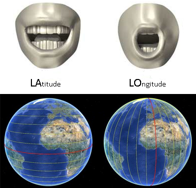
When you say the first syllable of the word "LAtitude" your mouth widens horizontally. Latitudinal lines also stretch horizontally across the earth (west to east).

When you say the first syllable of the word "LOngitude", your mouth stretches open vertically. Longitudinal lines also stretch vertically across the earth (south to north).

enter image description here

$\endgroup$
4
  • 3
    $\begingroup$ i managed to do the exact reverse with my mouth. So... ? $\endgroup$
    – user1066
    Commented Feb 11, 2017 at 6:16
  • $\begingroup$ so turn your head to the side when you do it then $\endgroup$
    – f.thorpe
    Commented Feb 12, 2017 at 3:30
  • 1
    $\begingroup$ Those images are creeping me out... Thanks man! $\endgroup$ Commented Feb 12, 2017 at 15:57
  • $\begingroup$ @Epicality Yeah, the ocean looks too big. $\endgroup$
    – Dan Z
    Commented Jan 10, 2021 at 6:22
5
$\begingroup$

I had the same problem. What seemed to set them firmly apart was the connection to a LADDER.

Ladder jives with the word latitude. So the lines of latitude are like climbing the rungs of a ladder. And the values of latitude are how high up (or down) you are.

Generally I just go with that, it automatically defines the other term... but if you do want to go further with longitude, I agree that using terms with LONG do the job. To get the longitude, you go ALONG the rungs LONGWAYS. The vertical lines are the hashmarks to show how far you've come along.

I'm convinced in my years thinking about this personally and then teaching that a big part of the challenge of any imagery/phrases is the confusion between whether you're talking about the line itself or values. It surely confused me to no end that values of latitude were north/south, while the lines of latitude were drawn east-west. I think/hope the ladder/latitude connection is a clear way to help people of all ages overcome the confusion.
$\endgroup$
4
$\begingroup$

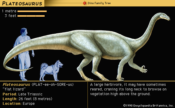
One way is to picture a long neck dinosaur. It's a bit of an unconventional connection, but the oddness is what helps me to remember it.

Plateosaurus

(The Editors of Encyclopædia Britannica. "Plateosaurus." Encyclopædia Britannica. Encyclopædia Britannica, Inc., 25 May 2010. Web.)

Longitude: A LONG neck dinosaur has a long neck that extend vertically upwards. The lines of longitude extend vertical on a map of the Earth.

Latitude: The back of a long neck dinosaur is relatively FLAT. The lines of latitude lay horizontal or "flat" on a map of the Earth.

TLDR; FLAT back, LONG neck. I hope this helps.

$\endgroup$
1
  • $\begingroup$ +1 I won't be able to remember the difference between lon and lat by this explanation but it really creative :-) . $\endgroup$ Commented Feb 11, 2017 at 22:07
2
$\begingroup$

I remember longitude it by the fact that it runs the long way around the earth. In other words all longitudes are diameters.

$\endgroup$
2
  • $\begingroup$ This is helpful, but when I'm thinking lat/long I'm thinking about the lines themselves, not the direction they are used....if that make any sense $\endgroup$ Commented Feb 12, 2017 at 16:00
  • $\begingroup$ Lines of longitude are half-circumferences, not diameters. It's not a bad way to remember, but not technically correct - every line of longitude is ~12,450 miles long, but most lines of latitude are longer than that. The equator, at 0 degrees latitude, runs the full circumference of the earth (24,900 miles). You have to go beyond 60 degrees latitude for the latitude lines to be shorter than longitude lines. $\endgroup$ Commented Jun 6, 2019 at 13:25
2
$\begingroup$

Easiest method I use is "Lat(itude) = Fat(itude)", imagining left-to-right lines of latitude looking like a fat belly (or belt) protruding over a tight belt.

That does the trick, but as a secondary mnemonic, I then imagine "Long" as a measure of tall/lankiness, as I'd never describe fatness/width as "long".

$\endgroup$
1
  • $\begingroup$ This is interesting because it's one step away from the memory aid I came up with when I was much younger, latitude = flatitude Repeating the rhyme dozens of times along with picturing that concept set it in my head well enough to remember permanently (and if I'm being honest, still pops up in my head after dealing with lat/lon values every day for almost two decades) $\endgroup$
    – dplmmr
    Commented Jun 6, 2019 at 3:38
1
$\begingroup$

Because longitudes run north south, I remember longitude with a rhyme of the first two letters of each: NoSoLo (North South Longitude).

$\endgroup$

Not the answer you're looking for? Browse other questions tagged or ask your own question.