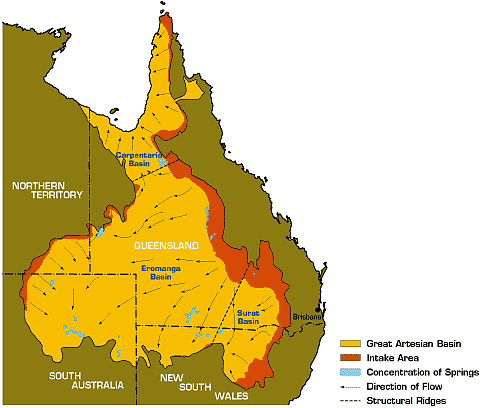
Areas where topography prevents the outflow of water are called closed basins. Is the GAB a closed basin? What if external bodies of water flowed in? Is that still "closed"?
-
$\begingroup$ See related question about inflows to the GAB: earthscience.stackexchange.com/questions/4466/… $\endgroup$– FredCommented Oct 8, 2015 at 0:18
-
$\begingroup$ Are you asking about surface water flow or groundwater flow? $\endgroup$– haresfurCommented Oct 9, 2015 at 3:18
3 Answers
In the far north of the Great Artesian Basin, there is groundwater outflow to the Gulf of Carpentaria. Everywhere else the aquifer behaves as a closed basin with outflow in the form of vertical seepage (e.g. to the Mound Springs of South Australia), artesian overflowing boreholes, and pumped boreholes. There may once have been hydraulic connection to the Southern Ocean, but that ceased several millions of years ago - not such a long time when one considers that the longest through-flow time of groundwater, from east to west, is about two million years.
-
$\begingroup$ Appreciate! According to your answer, the GAB as a whole is not a closed basin. Is there a maximum sub-region of GAB that only has vertical hydrologic exchange? I want to know a maximum region that the boundary has no lateral hydrologic exchange. $\endgroup$ Commented Oct 8, 2015 at 7:38
-
$\begingroup$ Not quite sure what you mean. All of the GAB has a lateral component in the form of lateral inflow from the recharge zone on the eastern boundary. Do you mean 'how much of the perimeter is effectively impervious'? $\endgroup$ Commented Oct 9, 2015 at 9:38
-
$\begingroup$ Actually I got confused about the definition of "closed basin" or "endorheic basin". Sorry about that. $\endgroup$ Commented Oct 10, 2015 at 1:25
-
1$\begingroup$ @GordonStanger what is the distinction between "Intake Area" and the GAB in that map? $\endgroup$ Commented Oct 25, 2015 at 22:18
-
$\begingroup$ I take intake area to be that plan area where recharge exceeds discharge. $\endgroup$ Commented Apr 4, 2016 at 19:13
One cannot discount the fact that the northern islands of Indonesia Timor island and Papua New Guinea are very high precipitation areas. It has been documented that there is high groundwater movement under Sahul shelf off Timor Island. The same Sahul shelf is also between Papua New Guinea and Australia. Since there is high groundwater movement off of Timor Island there is a high probability there is between Cape York and Papua New Guinea shore line. So GAB could be replenished by the Northern Islands of Timor and Papua New Guinea.
-
$\begingroup$ I think Occam's razor applies here. The recharge zones and direction of groundwater flow can be determined by piezometry. Isotopic data can also tell us something about groundwater age and the conditions when it was recharged. Without compelling evidence that the GAB water balance is poorly understood, there's no need to invoke hypothetical flows from the north, especially when there is evidence from drilling that the aquifer system doesn't extend right across the straits. $\endgroup$– Andy MCommented Nov 25, 2021 at 10:28
Most of the underlying strata beneath the Gulf of Carpentaria seabed is part of the Great Artesian Basin (GAB). It extends out to the Arafura Seabed and west of the Torres Strait islands. It may even extend or connect with paleochannels of Papua New Guinea's (PNG's) coastal areas. Geoscience Australia has maps showing the northern borderline or "country" maritime border areas of GAB. One could assume that GAB probably goes all the way to the PNG coastline. CSIRO and Geoscience do not provide maps detailing the geology under the Arafura Seabed or Torres Strait seabed close to the PNG coastline.
