7
$\begingroup$

I am running some test forecasts using WRF 3.6.1. and am having some problems with my grids. Specifically, I am specifying a parent and nest domain each with 25 points for longitude and latitude (so that there is a point right at the middle of the inner domain and the parent grid points are coincident with inner grid points with a 3:1 nesting ratio).

I would expect an output of 25 by 25 points for each domain. however, I am only getting 24 by 24 points as output. In fact if I look at the geom_em or met_em netcdf files generated by WPS I already get only grids with 24 by 24 points.

What's going on?

Here is the geogrid section of my namelist.wps file:

&geogrid
 parent_id         =   1,   1,
 parent_grid_ratio =   1,   3,
 i_parent_start    =   1,  9,
 j_parent_start    =   1,  9,
 s_we              =   1,  1,
 e_we              =  25, 25,
 s_sn              =   1,  1,
 e_sn              =  25,  25,
 geog_data_res     = '10m','2m',
 dx = 18000,
 dy = 18000,
 map_proj = 'lambert',
 ref_lat   =  53.526,
 ref_lon   =  -113.529,
 truelat1  =  53.526,
 truelat2  =  53.526,
 stand_lon =  -113.529,
 geog_data_path = '/media/data/WRF3.6.1/data/geog/'
/
$\endgroup$
2
  • $\begingroup$ Are all of the grids 24x24 or just the w and scalar grids? Is the u grid 25x24 and the v grid 24x25? I'm not familiar with WRFs grids but I have a hunch... $\endgroup$
    – casey
    Commented May 6, 2015 at 20:18
  • $\begingroup$ you are right. The XLONG, XLAT, T2, W variables are 24x24. The U and V are (as you have mentioned) 24x25 and 25x24 respectively. So it has something to do with grid staggering? $\endgroup$
    – piyushnz
    Commented May 6, 2015 at 20:46

1 Answer 1

6
$\begingroup$

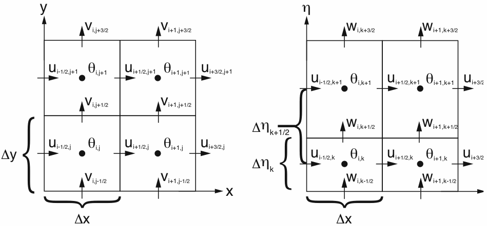
Your model grid is an Arakawa C grid:

enter image description here Image from Skamarock et al. A description of the Advanced Research WRF Version 3

It appears the geogrid grid generation uses the 25x25 as the furthest extents of the grid (and this is backed up by the grid maximum needing to be a multiple of the grid ratio +1). As a result, only the u and v variables will see 25 grid points and each only in one direction, east/west and north/south respectively. All other variables are located horizontally on the $\theta$, or scalar points in the middle of the grid boxes and there will only be 24 of these points in your setup leaving most of your grids having a horizontal dimensions of 24x24.

$\endgroup$
4
  • 2
    $\begingroup$ Exactly Right! If his start value had been 0 (instead of 1) then the end value would be 24. It is an inclusive extent range. $\endgroup$
    – f.thorpe
    Commented May 6, 2015 at 21:25
  • 1
    $\begingroup$ yes, I believe you are right. Reading the documentation again, I see it says that the e_we and e_sn values do in fact refer to an unstaggered grid. The terminology for the centered coordinates is the mass grid. I think I am doing the right thing with my nested domains, but I might have to rethink how to set up my grids to align with a validation point (originally I was going to centre the grid on such a point, but the mass grid then is not aligned...) $\endgroup$
    – piyushnz
    Commented May 6, 2015 at 21:39
  • 1
    $\begingroup$ @farrenthorpe Thanks. I had to think for a minute as the model I use (CM1) does it the other way around where you specify nx and ny for the scalar/mass points and it uses nx+1, ny+1 for the u,v grids. $\endgroup$
    – casey
    Commented May 6, 2015 at 23:05
  • 2
    $\begingroup$ I can confirm this answer is correct. $\endgroup$ Commented May 6, 2015 at 23:56

Your Answer

By clicking “Post Your Answer”, you agree to our terms of service and acknowledge you have read our privacy policy.

Not the answer you're looking for? Browse other questions tagged or ask your own question.