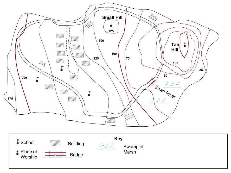
I have a question about a project I have for school. I have to make a topographic map of a made up island. I was wondering if the placement of the contour lines and the index lines are correct. Also if there are any mistake, can u point it out? I am not using the answers to the advantage of getting the project done, I am using to learn because we just started this in school. Thank you guys very much ]1
]1
-
1$\begingroup$ Please do not deface your posts. If you want to remove the post, delete it instead of editing it into nonsense. I have reverted your self-vandalism and restored the original version. $\endgroup$– caseyCommented Feb 5, 2016 at 17:00
-
$\begingroup$ No, they aren't correct. Some things are wrong, others just unlikely. Check the value of all the index lines. Imagine walking from east to west, crossing these contours. $\endgroup$– Matt HallCommented Feb 5, 2016 at 18:19
-
1$\begingroup$ For a map showing the whole of an island, all the contours must be closed loops. Think starting at the shore, where the 0 contour is the shoreline. $\endgroup$– jamesqfCommented Feb 5, 2016 at 18:54
-
$\begingroup$ Generally, it would be expected that contours of an island would form closed loops. My interpretation of your map is the area around Tan Hill looks plausible. The rest looks odd. From Swan River there appears to be a gently rising slope to the left of the river until it reaches an elevation of 100. There is a plateau at elevation 100, with a localized high of Small Hill, to the north of the plateau. From the plateau there is another rising slope, to the west, which peaks at elevation 200. The high elevation of 200 appears to be a knife ridge followed by a steep down slope to elevation 175 $\endgroup$– FredCommented Feb 6, 2016 at 0:57
-
2$\begingroup$ Island contours don't have to be closed loops; large parts of the island could be bound by cliffs. Maybe not likely, or safe, but reasonable. $\endgroup$– Matt HallCommented Feb 8, 2016 at 0:31
2 Answers
Map elements and signatures
- Every signature used in the map (except of elevation contour lines) has to be explained in the legend. For example, the dashed line is not explained.
- Your map needs a scale bar or at least a numeric scale.
- Look for better signatures for the street/path and choose one for the river.
- To complete it, a topographic map is always better with a coordinate grid resp. coordinate information in labels at the map frame.
- You could add a north arrow.
- To be completely correct, the map would need an information about the used projection and geodesic datum.
- If the map is created to be stand-alone later, don't forget to give it a title, date and information about author and cartographic survey or data source.
- The labels of the contour lines are normally orientated parallel to the lines. The direction is chosed so that you'd be able to read the labels naturally while walking uphill.
- Think about using an area signature for the swamp instead of symbols representing points.
- Optionally think about different area colours for either the water surface or the land surface; this makes it easier to differentiate between them.
"Worldbuilding" issues (if the map's content is fictional)
- Guessing the scale with the help of the houses: The most southern houses and maybe even the northern ones are very, very close to the coast. Normally, you'll have a beach or cliffs or an anthropogenic shoreline leaving at least some space to the coast.
- Related to this, your elevation contour lines needs to be modified, once around the island's shore.
- Nearly all houses have the same size.
- Imagine the solar radiation: The houses in the north do all have the same orientation and stand, seen from south to north, at the same elevation. Therefore, they would experience much less solar radiation.
- Unless the marked houses aren't big community houses, there might be too many schools for the number of inhabitants.
- There is no transport infrastructure like a harbor or at least a landing stage for boats.
Some hints to get you thinking.
Remember contours are lines joining points of the same elevation.
Let's say the island is in the ocean - what is the elevation of the shore-line around the island? If it is in a lake above sea level, would the elevation of the shore be different in different places?
So could a contour line run into the shore the way you have drawn them?
You have closed the contours around the hills - good. But what happens in low lying areas like the swamp? Wouldn't the land rise up on either side of the swamp? Would that mean that the contours mostly go around it? The contours might not close completely around the low-land the way they would around a hill-top unless you have a closed basin but they will spread out at flat areas. Think about working up from the shore as well as working down from the hills.
You have a River labeled but not drawn in. Maybe draw in where you think the river flows (hint rivers usually run in valleys and water flows downhill). This is kind of hard to visualise, but if you have a river valley running down a slope, the contour line will 'deflect' upstream where it crosses the river. Similarly a contour line will deflect away from the peak of a hill when it crosses a ridgeline. Try looking at a contour map of an area you know and see how it works.