5
$\begingroup$

According to Wikipedia, Indonesian Throughflow passes Lombok Strait from north to south bringing water mass from the Pacific Ocean to the Indian Ocean. enter image description here

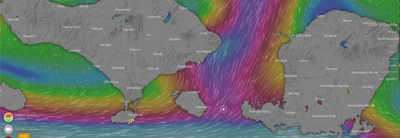
But when I the checked currents map on windy.com I found that current's direction is opposite - from south to north. So how can it be explained?

enter image description here

$\endgroup$
4
  • $\begingroup$ The Wiki diagram only shows the average flow ! Temporary reversals of the flow are therefore nothing unusual. $\endgroup$
    – Weiss
    Commented Jan 2, 2023 at 17:25
  • $\begingroup$ does it mean that reversal in 180 degree for oceanic flow are ok? $\endgroup$
    – pacman
    Commented Jan 3, 2023 at 1:46
  • $\begingroup$ arakiri did answer your question much better than me $\endgroup$
    – Weiss
    Commented Jan 4, 2023 at 9:21
  • $\begingroup$ @pacman, you have to be careful with windy's currents. They misrepresent the information they are providing: community.windy.com/topic/5848/currents-wrong-data $\endgroup$
    – arkaia
    Commented Jan 10, 2023 at 4:34

1 Answer 1

6
$\begingroup$

The average conditions of the Indonesian Throughflow (ITF) are well-represented by the top figure. The transport varies significantly throughout the year. One main driver of the change in transport magnitude is the Monsoon. During the Indo-Australian Monsoon (November-February), westerly winds partly counteract the ITF transport, especially in the upper part of the water column. During the Southwest Monsoon (June-August), southeasterly winds over Indonesia drive additional flow through the ITF. In the transition months, downwelling favorable winds in the eastern Indian Ocean increase sea level in the southwest part of the ITF region, reducing the pressure gradient from the Pacific into the Indian Ocean and causing a minimum ITF transport. The sporadic eastward current in the Indian Ocean is referred to as the Wyrtki jet.

During times of reduced ITF transport, reversals of the ITF can occurred, especially in some of the smaller branches like the flow through Lombok Strait. The caused of these reversals is usually associated with specific weather systems. For example, Shinoda et al. (2012) showed an episode of flow reversal during May 2004. The development of a northward current anomaly can be seen in the sea surface height and current anomaly map.
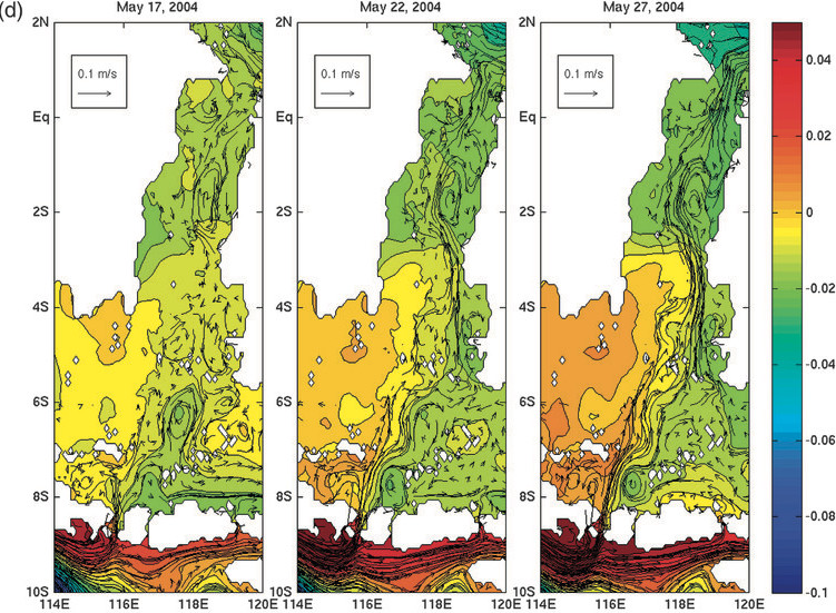
Shinoda et al. 2012 Figure 5d Sea Surface Height (shading; m) and upper-ocean (average over 50–250-m depths) velocity (vectors) anomalies during 9–30 May 2004 relative to the mean of April–June 2004. Source Shinoda et al. (2012).

$\endgroup$
2
  • $\begingroup$ thanks for such a detailed answer! Also wanted to ask if ITF is deep water flow. I thought that windy.com represents only current on the surface. My suggestion was that two pictures in my question represent different levels of water - depth for ITF and surface current generated by local winds. $\endgroup$
    – pacman
    Commented Jan 10, 2023 at 2:45
  • 1
    $\begingroup$ @pacman, you have to be careful with windy's currents. They misrepresent the information they are providing: community.windy.com/topic/5848/currents-wrong-data $\endgroup$
    – arkaia
    Commented Jan 10, 2023 at 4:34

Your Answer

By clicking “Post Your Answer”, you agree to our terms of service and acknowledge you have read our privacy policy.

Not the answer you're looking for? Browse other questions tagged or ask your own question.