1
$\begingroup$

What I am asking, is exactly the opposite of the yearly rain. It is well measured and it has century long databases.

Consider a given, generally dry area. What I am trying to know: if this area wouldn't be dry, but it would be an open water surface (for example, a sea), but without any water resupply (i.e. rain), what would be the yearly level loss by evaporation?

I think, this information would be useful to calculate the irrigation need of not arable territories because of the lack of rain.

Additional difficulty: in case of larger areas, this evaporation rate would be probably smaller, because the winds in the central regions get moisture on the borders.

I suspect, calculating this would require a relative complex weather simulation, which is not available on the enthusiast level. But maybe some fist rule, estimation or already existing databases can exist.
$\endgroup$

2 Answers 2

6
$\begingroup$

What you are asking is one of the most difficult issues in hydrology. The evaporation from open water is a function of air temperature, water temperature, humidity, wind speed and fetch, water depth, water salinity, degree of thermal stratification, and boundary effects (as you correctly point out). It is certainly not a trivial calculation! As a first approximation you can apply an empirical coefficient to class-A pan evaporation data, but don't expect any great accuracy.

But then you progress towards a further aim of calculating a potential irrigation need. For this purpose I would say that calculating open water evaporation is completely the wrong approach. Rather, calculate the potential evapotranspiration ('ET0'), and then apply appropriate crop factors, as explained in the FAO documentation: http://www.fao.org/docrep/s2022e/s2022e07.htm
Calculating ET0 is best done using the Penmann-Monteith equation, which is horribly complicated, but there are web sites where you can do the calculations on line. You will need monthly or dekad climate data for the crop(s) you envisage growing. This will be max and min temperature, humidity, average wind speed and average daily hours of bright sunshine. You will also need latitude, longitude and altitude to estimate the solar radiation. Even with all this data, it is a fairly lengthy calculation, but it is your best bet at realistic crop water requirements.

$\endgroup$
1
  • $\begingroup$ You can also add in the recent discovery that light can cause evaporation without the need for heat transfer which makes evaporation far more efficent than previously beleived. researchgate.net/publication/…. $\endgroup$
    – John
    Commented Jun 17 at 0:39
3
$\begingroup$

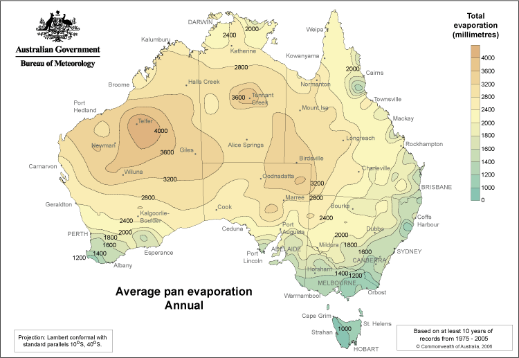
Depending on the location, evaporation data is collected by some meteorological organisations. Class A pans or Symon's pans are used to collect daily evaporation data for selected sites.

In Australia, such data is gridded to produce images like this one, from the Australian Bureau of Meteorology.

enter image description here

$\endgroup$
1
  • $\begingroup$ Fred; is the Australian data face value or corrected? If the former, then we need to be clear that we need to apply pan coefficients to get the true evaporation rate, and that the coefficients vary from about 4.5 to 8.5,according to the degree of exposure at each evaporation pan. $\endgroup$ Commented Jun 7, 2016 at 9:29

Your Answer

By clicking “Post Your Answer”, you agree to our terms of service and acknowledge you have read our privacy policy.

Not the answer you're looking for? Browse other questions tagged or ask your own question.