I've just seen the LiveScience article 70-Mile-Long Crack Opens Up in Anatarctica. I'm not sure if the title is a bit sensational or not, the crack is in an ice shelf, not the continent of Antarctica.
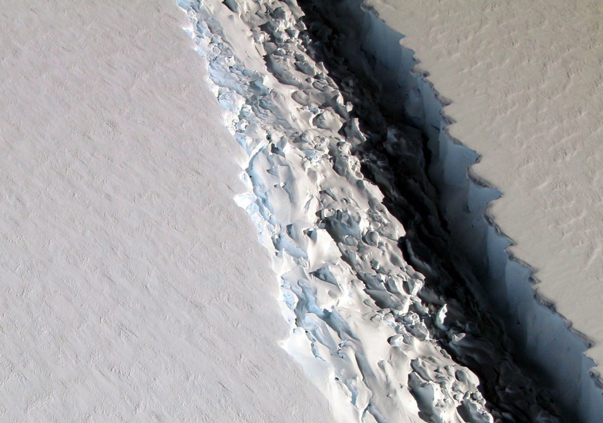
An ominous crack in an Antarctic ice shelf as wide as a football field is long takes on an otherworldly beauty in a new aerial image.
Snapped by scientists on NASA's IceBridge mission, the shot shows a rift in Larsen C, an ice shelf that is floating off the Antarctic Peninsula. When the crack eventually spreads across the entire ice shelf, it will create an iceberg the size of the state of Delaware, according to IceBridge. That's around 2,491 square miles (6,451 square kilometers).
As of Nov. 10, when the IceBridge scientists observed this crack, it was 70 miles (112 km) long and more than 300 feet (91 meters) wide. The dark depths of the crack plunge down about a third of a mile (0.5 km), all the way through the ice to the ocean below.
[...] Larsen C is Antarctica's fourth-largest ice shelf, and it holds back the land-based glaciers just behind it: Once the ice shelf goes, those slow-flowing glaciers have one less barrier in their journey toward the sea.
My primary question: is this a remarkable event, or something that over time happens regularly? Isn't this just a natural part of "those slow-flowing glaciers... journey toward the sea." ?
I'm also wondering 1) Is an iceberg the size of Delaware actually remarkable, or something that just happens from time-to-time? And 2) how they (actually) know the crack goes all the way to the ocean - can they actually see the water in images, or is this a hypothesis based on understanding of cracks of this length and width? I can ask as a separate questions if it's too much to ask here.
above: Image from here. "A huge crack can be seen in the Antarctic Peninsula's Larsen C ice shelf in this aerial image snapped on Nov. 10, 2016, as part of NASA's IceBridge mission. Credit: NASA/John Sonntag"
update:
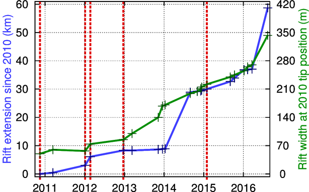
The rift continues to be tracked. If I understand correctly, it is now over 350 meters wide and growing:
above: From A growing rift on Larsen C at the Project MIDAS website.
More can be read about NASA's operation Ice Bridge program at its official website. These are a series of areal flights over antarctic regionss to collect images and data. The image above of the crack in the Larsen-C ice shelf was a featured photo and more can be read about it here. In the image gallery the caption states:
Rift in Antarctica's Larsen C Ice Shelf
On Nov. 10, 2016, scientists on NASA's IceBridge mission photographed an oblique view of a massive rift in the Antarctic Peninsula's Larsen C ice shelf. Icebridge, an airborne survey of polar ice, completed an eighth consecutive Antarctic deployment on Nov. 18.
The photo was also featured in @NASA_ICE.
A short video explaining the mission and showing details of the aircraft's science equipment can be seen below (and is linked here):


