19
$\begingroup$

Figure 1.12 from the IPCC AR5 WG1 report (reproduced below) illustrates the different instruments that have been used for weather forecasting.

Most of the methods have been in continuous use since their inception, except one: kites were used, but later disbanded.

Why is this so? This Monash university article from 1999 makes the point that they are superseded by radiosondes and aircraft. However, atmospheric measurements on aircraft are very expensive and mainly used for research as opposed to operational weather forecasting; and, unlike weather kites, they do not (normally) fly in the boundary layer¹. Radiosondes are only launched once or twice per 24 hours per location. Passive (operational) space-borne measurements have a lower vertical resolution, in particular near the boundary layer. I imagine that kites should provide a low-cost, high-resolution (both temporally and vertically) profile of the boundary layer. Why is it they are not really used operationally anymore?
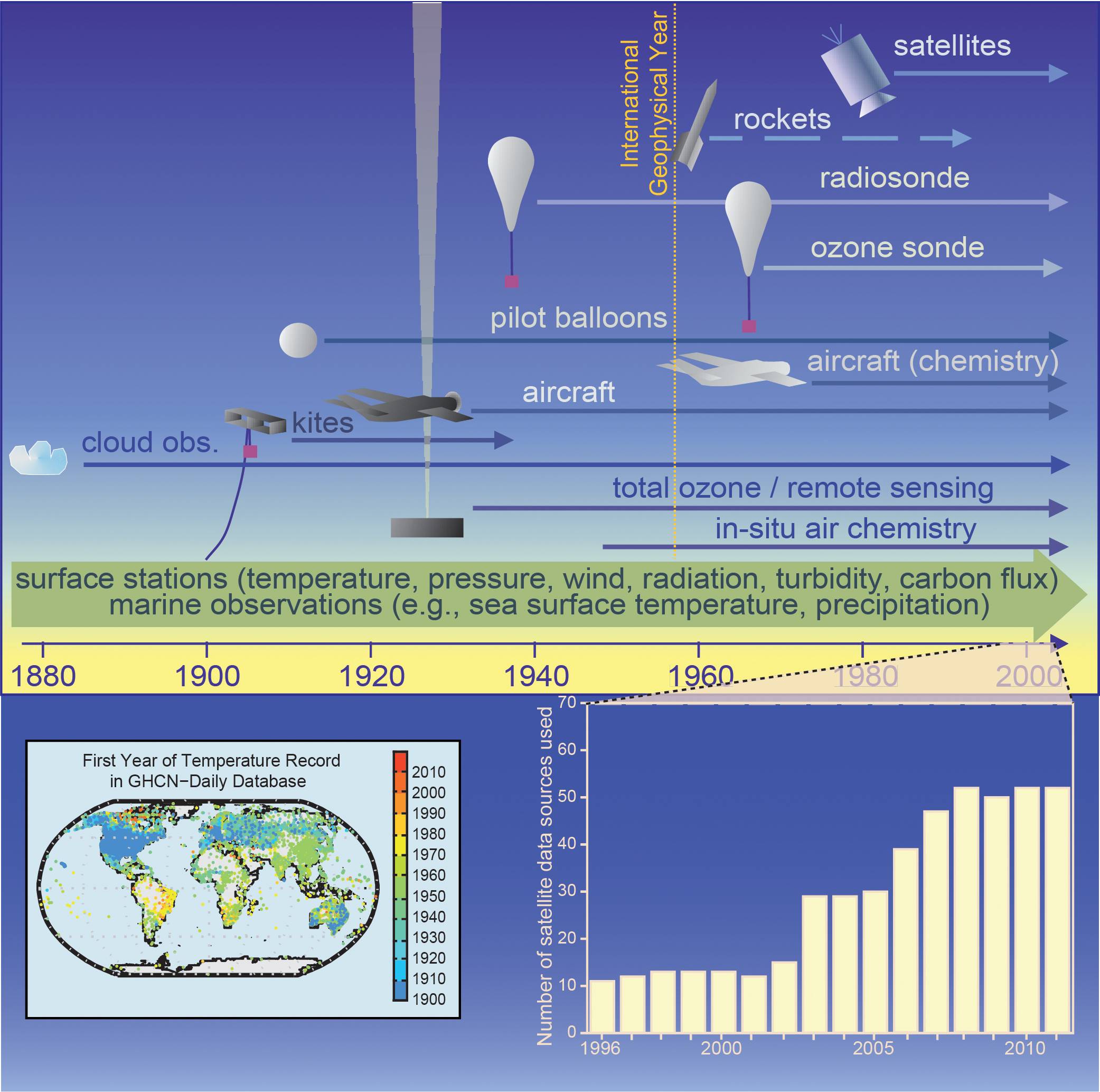
IPCC AR5 WG1 Figure 1.12
Figure 1.12 | Development of capabilities of observations. Top: Changes in the mix and increasing diversity of observations over time create challenges for a consistent climate record (adapted from Brönnimann et al., 2008). Bottom left: First year of temperature data in Global Historical Climatology Network (GHCN) daily database (available at http://www.ncdc.noaa.gov/oa/climate/ghcn-daily/; Menne et al., 2012). Bottom right: Number of satellite instruments from which data have been assimilated in the European Centre for Medium-Range Weather Forecasts production streams for each year from 1996 to 2010. This figure is used as an example to demonstrate the fivefold increase in the usage of satellite data over this time period. Figure reference: Cubasch, U., D. Wuebbles, D. Chen, M.C. Facchini, D. Frame, N. Mahowald and J.-G. Winther, 2013: Introduction. In: Climate Change 2013: The Physical Science Basis. Contribution of Working Group I to the Fifth Assessment Report of the Intergovernmental Panel on Climate Change [Stocker, T.F., D. Qin, G.-K. Plattner, M. Tignor, S.K. Allen, J. Boschung, A. Nauels, Y. Xia, V. Bex and P.M. Midgley (eds.)]. Cambridge University Press, Cambridge, United Kingdom and New York, NY, USA.


¹Research aircraft sometimes do. Flying in a full-sized jet 20 metre above the ocean surface is an interesting experience!

$\endgroup$
10
  • 1
    $\begingroup$ were they not merely replaced with tall buildings, guyed masts, etc... being fixed structures from which reliable wind data could be recorded from. $\endgroup$
    – Siv
    Commented Apr 21, 2014 at 19:31
  • 1
    $\begingroup$ Wind data from sensors on buildings are strongly disturbed by the flow modifications induced by the buildings. $\endgroup$
    – BHF
    Commented Apr 21, 2014 at 19:53
  • $\begingroup$ solid structures, fixed structures, then perhaps $\endgroup$
    – Siv
    Commented Apr 21, 2014 at 19:55
  • $\begingroup$ Think you need to rethink your assumptions, or at least state them. For example, your chart appears to show they haven't been used since roughly 1940, are you asking why they're not used now, or for the past 70+ years? Where would the sensors be, how much would they weight, etc? Where is wind data most needed and what if any risks are related to using kites in those locations? Would the kite be manned or unmanned? Honestly, question seems way to open ended to me as it is currently; though maybe I'm wrong, or have misunderstood the intent of your question. $\endgroup$
    – blunders
    Commented May 8, 2014 at 2:35
  • $\begingroup$ Also, in my opinion, tethered balloons are not comparable to kites. $\endgroup$
    – blunders
    Commented May 8, 2014 at 3:12

1 Answer 1

12
$\begingroup$

Most data we collect about weather is done regularly and for all altitudes of the troposphere. Kites, though, are at the mercy of the weather and do not fly high enough. So when there is ice or snow or other meteorological conditions that don't allow a kite to fly, you get no data. We now use methods to measure the weather that don't break in bad weather. The answer to your question is succinctly put in this NOAA webpage where they state these difficulties with kites:

  • The average altitude reached was only about 3 km.
  • Data could not be evaluated until after the kite was reeled in...
  • Observations could only be taken in good weather with winds neither too light or too strong.
  • There was danger of the kite breaking away and endangering lives and property.

In the 1940s, weather balloons were being released and could gather an entire profile of data in all weather conditions. This is far superior to a kite. That being said, some people do still use kites: High-Flying Science, with Strings Attached.

$\endgroup$
1
  • 4
    $\begingroup$ Sounds like #2 should no longer be valid today, but the other points make sense. $\endgroup$
    – gerrit
    Commented Jun 3, 2014 at 19:44

Your Answer

By clicking “Post Your Answer”, you agree to our terms of service and acknowledge you have read our privacy policy.

Not the answer you're looking for? Browse other questions tagged or ask your own question.