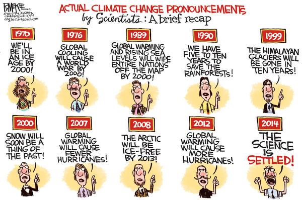
First things first. Global "Weirding" is very difficult to quantify. That doesn't mean it's not happening, but it's inexact. The idea came from climate models, which produced a lot of unexpected variations as opposed to more smooth and consistent warming and weather patterns are so complicated that there's still a lot of unknowns in this area.
Warmer waters mean typhoons can form more often, so in locations where
extreme weather is also caused by typhoons they will see this more
often
Typhoons/Hurricanes are formed not just by warm water but by warm air and wind direction. If the wind is too strong, the hurricane doesn't form, it needs to build and as it builds, begin to spin. That's a dummies explanation, more details here
Warmer water can make hurricanes grow larger (unclear if it makes the wind blow faster too, it might). One of the fun little jokes made about global warming is that in the IPCC's 4th assessment report (4AR) they predicted fewer hurricanes and in the 5th (5AR) they predicted more, though both were stated with some uncertainty and in the 4AR they predicted fewer with a chance of larger so those predictions aren't nearly as contradictory as this cartoon writers tries to make it sound.

I personally trust 5AR over 4AR cause it's had 7 more years of research behind it, but whatever ends up being true, predicting hurricanes is complicated. Short article on the debate of cause of the apparent recent increase here
Warmer air can transport more water and since steam pressure rises
greater than linear with temperature, the same temp. swing around a
high mean means that more water can precipitate.
I'm not sure about stream pressure, though warmer air can hold significantly more water vapor, so that I agree with.
Every 1 ° warmer, the atmosphere can hold in saturation about 6% more water. So warmer air can hold quite significantly more water and as a result, lead to larger rain storms, though it's not just air temperature, but temperature variation as the warm air rises, etc. But more precipitation per storm is a very likely consequence of man made climate change. Source.
Also, while the Earth has warmed less than 1 ° C so far, most of the surface temperature over land has warmed over 1 ° C (1.53 ° C on average - see here) and it's the rainfall over land that affects us. This means that the atmosphere over the land can hold as much as 10% more water on average than it did at pre-climate change levels. Now, the temperature increase is lower in the upper atmosphere, so it's not really 10%. but we've seen a few percent increase in how much water our atmosphere can store over land over just the last few decades and that's expected to continue to increase.
Water evaporation and atmospheric water-vapor replenishment is trickier and depends on a few factors, river flow rate is based on rainfall and snow-melt upstream, wind speed and plant transpiration are also important. Some people say CO2 is plant food but it's not that simple. Plants need to take in oxygen to capture CO2 which they use to grow. Sunlight and soil neutralists are the actually the "food" for plants, CO2 is what they use to grow and with higher levels of CO2 in the air, they need to take in less atmosphere to get what they need and as a result, they lose less water, so less water is returned to the atmosphere from forests and trees, as CO2 increases.
So, in a nutshell, the global warmed atmosphere on average can hold more water, it can also take more time for the atmosphere "fill up again" after a rainfall or after passing over high mountains and dropping a lot of water-vapor. That's why you get more floods and more droughts. That much is simple physics.
If snow melt is high, that can lead to greater river flow and more flooding, and snow tends to fall in greater amounts with more water-vapor in the air. There's a number of factors.
That strange 5 feet of snow event on Buffalo in 2014 happened when cold air blew over warm great lakes and the temperature difference caused the wind to draw a lot of water off the lakes. Which, as it blew inland a mile or two, it quickly turned to snow and not the houses on the lake, but the houses a mile away from the lake got covered in snow. The lake effect isn't unique to climate change. It happened in the 1940s and 1970s, but warm lakes and a cold blast of air are the 2 drivers. 2014 was perfect for that with the polar vortex and the warm temperature colliding. It was (I think) the largest lake effect Buffalo has on record.
Cool video here,
I often hear a statement to the effect that more energy in a weather
system means it has more extreme 'swings' in its behaviour. I find
this rather opaque and unconvincing.
I think I agree with you here. More "energy" is at best, vague, and it explains nothing.
Water vapor condensation is one way that air temperature can rapidly change. Condensation/cloud formation releases heat so more water vapor can play a role in faster temperature change, but I'm not sure how big a factor that is.
Changes in ocean currents, perhaps caused by salinization changes and glacier melt can have significant effects. Europe's moderate winters relative to high latitude are in large part caused by the gulf-stream and the gulf-stream may be slowing, article here. There's still some uncertainty on the extent of this effect, but there appears to be a connection.
The Polar Vortex may also be growing as a result of climate change, based on some complicated models. Despite the earth being warmer, harsh winters in some northern locations are still possible based on weather patterns. Key point from article here:
As strange as it sounds, Kim believes the intense cold air outbreaks
in recent winters across Europe, Asia, and North America are, in his
words, “a side effect of global warming.”
In 2100, we'll see more extreme heat events relative to 2015 mean
temperatures or
In 2100 we'll see more extreme heat events relative to 2100 mean
temperatures
This is a tough one.
First point is that there really is no 2015 mean in terms of temperature. We can generate a global average temperature for 2015, but local temperature fluctuates too much to have a 2015 standard. Temperature variation vs a standard is generally measured against a baseline over a few decades. For example, see chart below. (I couldn't get it to embed), but it compares 2014 local temperature to a baseline of 30 years, 1981-2010.
https://www.ncdc.noaa.gov/sotc/service/global/map-blended-mntp/201401.gif
If your question is rewritten as, will 2015, 2016, 2017, 2018, 2019, etc, compared to a 1981-2010 baseline have fewer extremes and look less "weird" than 2100, 2101, 2102, 2103, 2104, etc compared to a 2066-2095 baseline, then that's an interesting question but very hard to answer. Individual years will be hit or miss, but on average, …hard to say.
As ice melt increases and as oceans continue to store heat and slowly grow warmer the weird weather variation could increase, but as CO2 levels begin to perhaps at some point, stop rising and reach a leveling off, we might see a decrease in "weirdness" compared to previous years, though the planet would still be warmer, but the rate of change might drop, so the best answer I can give you is that it could go either way.
The IPCC models suggest a gradual increase in the rate of warming for surface temperatures between now and 2100, as well as an expected increase in sea level rise but that corresponds to a steady increase in CO2. The future CO2 growth rate could be a factor.
Guesses aside, when the experts say that weather will continue to get stranger, they are talking about compared to a consistent baseline, not a moving baseline cause that's a safer prediction, so your first sentence is the prediction that's usually put forth, but your 2nd sentence has a ballparkish 50% chance of being true too.
At some point the degree of weirdness has to level off simply because nothing builds indefinitely and for now global "weirding" appears to be gradually increasing, though as far as I know, precise measurements don't really exist. It's too hard to quantify.
