7
$\begingroup$

update: Searching "Rub' al Khali Empty Quarter" found "Q2: What are sabkhas?" in https://www.geocaching.com/geocache/GC6BYQ0_rub-al-khali-the-empty-quarter which seems to be related.

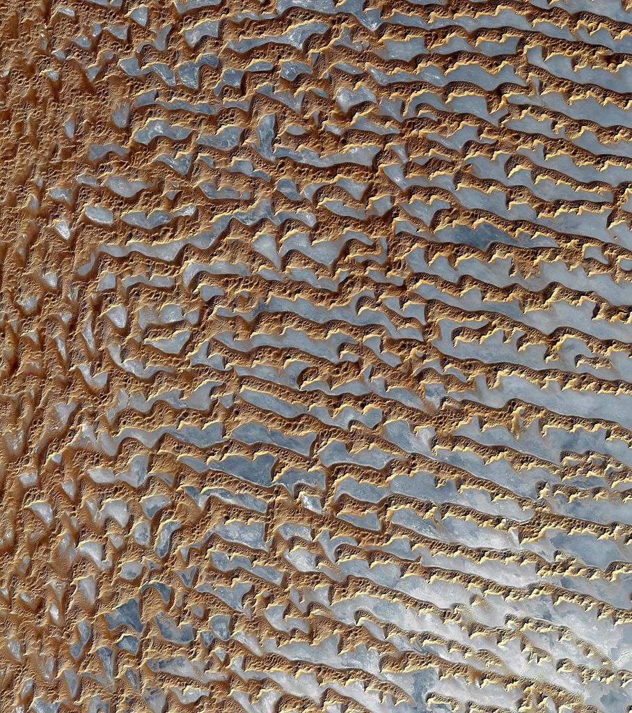
From the NASA image gallery; and also Catalog Page for PIA11084 where the caption says:

Original Caption Released with Image: The Rub' al Khali is one of the largest sand deserts in the world, encompassing most of the southern third of the Arabian Peninsula. It includes parts of Oman, United Arab Emirates, and Yemen. The desert covers 650,000 square kilometers, more than the area of France. Largely unexplored until recently, the desert is 1000 km long and 500 km wide. The first documented journeys made by Westerners were those of Bertram Thomas in 1931 and St. John Philby in 1932. With daytime temperatures reaching 55 degrees Celsius, and dunes taller than 330 meters, the desert may be one of the most forbidding places on Earth.

The image was acquired December 2, 2005, covers an area of 54.8 x 61.9 km, and is located near 20.7 degrees north latitude, 53.6 degrees east longitude.

The U.S. science team is located at NASA's Jet Propulsion Laboratory, Pasadena, Calif. The Terra mission is part of NASA's Science Mission Directorate.

Image Credit: NASA/GSFC/METI/ERSDAC/JAROS, and U.S./Japan ASTER Science Team

Image Addition Date: 2008-08-08

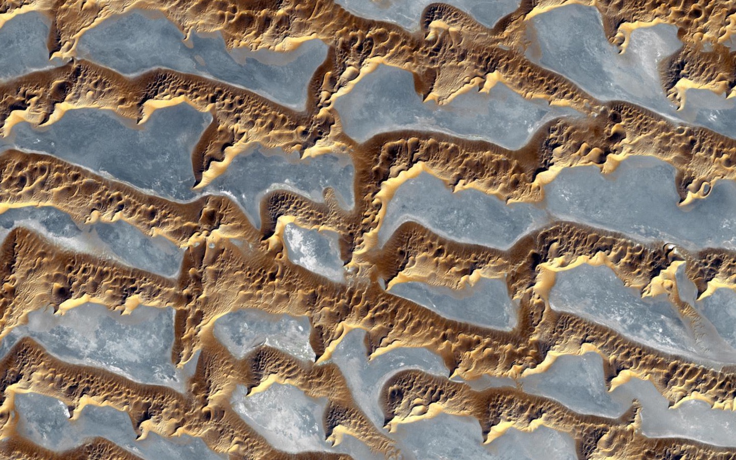
Question: The pattern shown in this image has an amazing amount of approximate repetition of shapes; long straight segments with a periodicity of about 2 kilometers, "stair steps" northward and sharp, pointy extensions southward. Is there any understanding how such a distinct pattern could be formed?


below: "Rub' al Khali (Arabian Empty Quarter) sand dunes imaged by Terra (EOS AM-1)" cropped and full sized (reduced resolution) images from here.

enter image description here

enter image description here

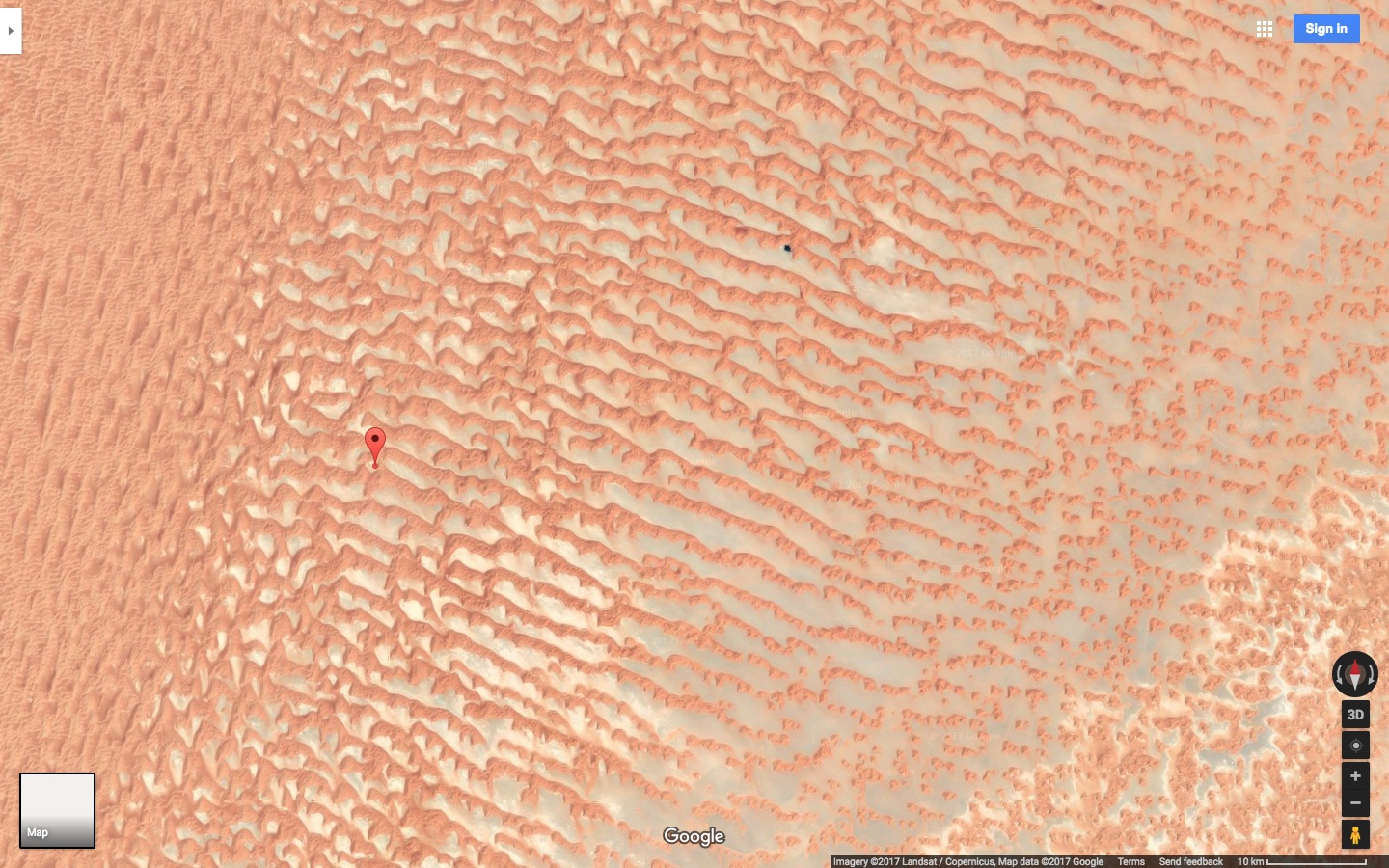
below: screen shot from Google Maps confirming orientation. Marker is at 20.7N, 53.6E.
enter image description here

$\endgroup$
6
  • $\begingroup$ Suggestions for tags welcomed. $\endgroup$
    – uhoh
    Commented Jun 19, 2017 at 5:24
  • 1
    $\begingroup$ what are the light-colored/reflective areas? $\endgroup$
    – Colin
    Commented Jun 19, 2017 at 7:19
  • $\begingroup$ @ColinZwanziger I'm out of my depth here. I would think the flat areas are sand and the raised areas are rock, but the NASA caption calls the raised areas "dunes". It's a really good question! $\endgroup$
    – uhoh
    Commented Jun 19, 2017 at 7:26
  • 1
    $\begingroup$ I'm reasonably certain that those are dunes (ergs) where evaporite salt has formed in the troughs between the dunes, thus giving that somewhat reflective white color. Reasonably certain, but not certain enough to post as an answer. $\endgroup$
    – kingledion
    Commented Jun 19, 2017 at 11:27
  • $\begingroup$ @kingledion I'm wondering if this should be two separate questions - what is this stuff, and why the highly distinct, repeating pattern. But I suppose the answer to the latter requires the former. The Google Earth image is probably fairly close to the visible appearance. The satellite image is from ASTER and with 14 spectral channels from visible all the way to thermal IR, this might be a false color (thus the google Earth image for reference/comparison). Erg, I learned a new word today, thanks! ;) $\endgroup$
    – uhoh
    Commented Jun 19, 2017 at 12:58

2 Answers 2

5
$\begingroup$

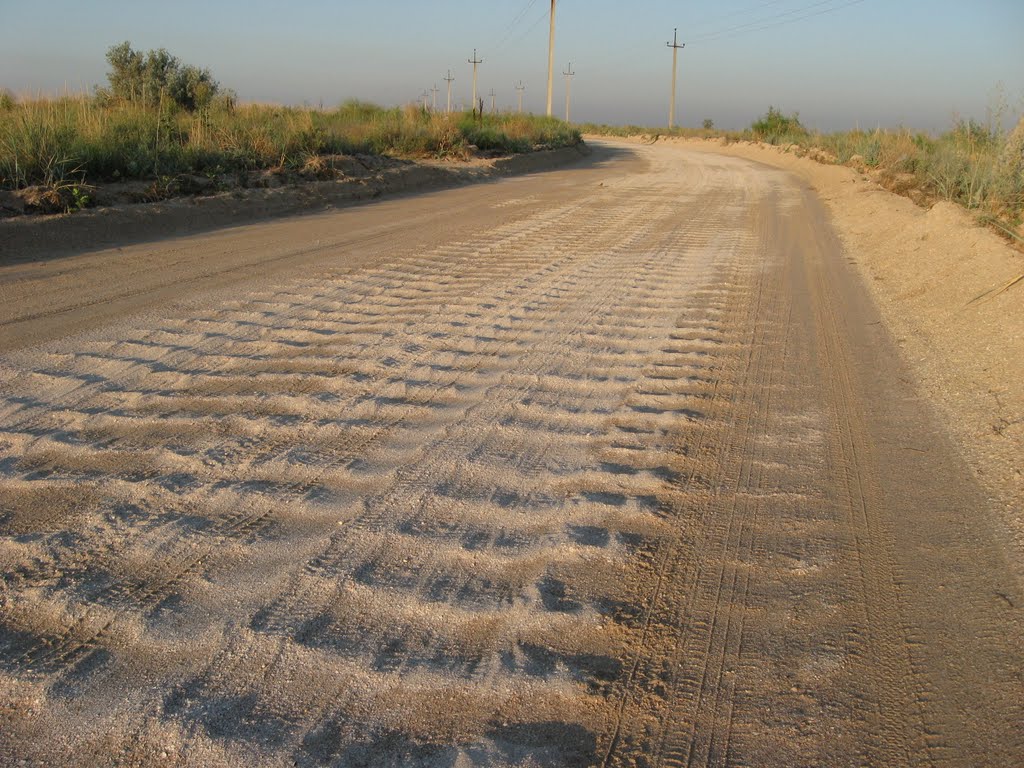
This a great example of "self-organization" in a geomorphological system; this one an oscillating system at a fairly large scale. On a much smaller scale, you find similar structures on sand dune surfaces themselves as well as dry dusty dirt roads:

enter image description here

Self organization (and its scaling) is a complex process delicately dependent on just a few variables, in the case of desert dunes, wind carrying capacity, and critically, bed surface. (You can also find examples of oscillating chemical self organization in rocks when, for example, you see "tree-rings" around plagioclase crystals in anorthosites.)

The hidden (and surprising) complexity of self organization in natural systems is reflected in the difficulty in modelling these behaviors. In the case of small sand dunes:

...a complex process of ripple coalescence is responsible for this evolution of the ripple field. Small, fast-moving ripples catch up with and are absorbed by larger, slower forms, each such merger resulting in a growth of the mean wavelength and a decline in the relative dispersion of the wavelengths.

This mechanism may figure in modelling the formation of large dune fields:

Because dunes reorient only at their crest terminations with a change in wind regime, the rate of formation of a new pattern of small dunes is typically faster than the rate of reorientation of the existing pattern, resulting in the superposition of simple patterns to give rise to complex patterns. Complex patterns are distinct from spatial changes in a simple pattern, and from the type of superposition that characterizes compound/complex dunes.

There are literally tons of examples of self organization in earth systems, at all kinds of scales, but that NASA image is a stunner!

$\endgroup$
7
  • $\begingroup$ Ugh, anyone who's driven a car over a washboard road will cringe seeing that photo :) This is a great introduction to self-organization and periodicity. +1 However, I'm still interested if there has been any kind of possible explanation for, or discussions of the "stair steps" northward and sharp, pointy extensions southward. So I've asked Is there any understanding how such a distinct pattern could be formed? about the stair steps and pointy extensions. $\endgroup$
    – uhoh
    Commented Jun 20, 2017 at 3:06
  • $\begingroup$ I'll stop by the library in a few days and take a look at the papers. Thanks for the links! $\endgroup$
    – uhoh
    Commented Jun 20, 2017 at 3:12
  • $\begingroup$ Pointy ends are a standard feature of many dunes (even on Mars!), particularly Barchan dunes: google.com/…. If you can imagine winds shifting to one direction for a prolongued period, then shifting back, you can easily imagine these pointy tails smeared and superposed in complex geometries. $\endgroup$ Commented Jun 20, 2017 at 3:15
  • $\begingroup$ OK, that's great! Do you think it's possible to add that back into the answer? I thought the points and steps were really unique. If they are not, then that information in the answer could wrap this question up nicely. $\endgroup$
    – uhoh
    Commented Jun 20, 2017 at 3:17
  • $\begingroup$ No edit necessary; it's already in there! ......."Because dunes reorient only at their crest terminations with a change in wind regime, the rate of formation of a new pattern of small dunes is typically faster than the rate of reorientation of the existing pattern, resulting in the superposition of simple patterns to give rise to complex patterns. Complex patterns are distinct from spatial changes in a simple pattern, and from the type of superposition that characterizes compound/complex dunes." $\endgroup$ Commented Jun 20, 2017 at 3:31
2
$\begingroup$

NASA has just published (16 June 2018) a similar picture on its Earth Observatory website.

The pictures in the question were taken after Tropical Cyclone Mekunu passed over the region in May 2018.

The grey, metallic looking shapes are interdune sand flats filled with rain water.

$\endgroup$
1

Your Answer

By clicking “Post Your Answer”, you agree to our terms of service and acknowledge you have read our privacy policy.

Not the answer you're looking for? Browse other questions tagged or ask your own question.